Local Geology
Geology Basics:
Within the Middle Trinity Groundwater Conservation District (MTGCD), two principal aquifer systems supply groundwater: the Cretaceous‑age Trinity Aquifer and the older, Paleozoic‑age Cross Timbers Aquifer. While the majority of pumped water supports irrigation, municipal and livestock demands also represent significant consumptive uses.
Trinity Aquifer
The Trinity Aquifer consists of three stacked formations—Hosston (oldest), Hensell, and Paluxy (youngest)—all deposited in riverine and coastal‑plain settings during Cretaceous sea‐level fluctuations. These units are composed predominantly of sands and sandstones. Within the District, water quality ranges from fresh to slightly saline. Recharge and discharge rates vary by formation, and long‑term monitoring shows a steady decline in water levels—especially in the eastern sectors.
Cross Timbers Aquifer
Lying beneath the Trinity, the Cross Timbers Aquifer is composed of the Strawn, Canyon, Cisco, and Wichita groups. In western Comanche and Erath counties, erosion has stripped away overlying Cretaceous rocks, exposing the Strawn and Canyon units at the surface. This aquifer comprises interbedded limestones, shales, and sandstones deposited in riverine and deltaic environments. Aquifer geometry and hydraulic properties are highly heterogeneous, leading to variable recharge, discharge, and water‐quality conditions—from fresh near recharge zones to brackish downdip. Precipitation‑driven recharge averages just 0.1 inches per year (≈0.3% of mean annual rainfall) across the aquifer (Nicot et al., 2013).
Well Distribution
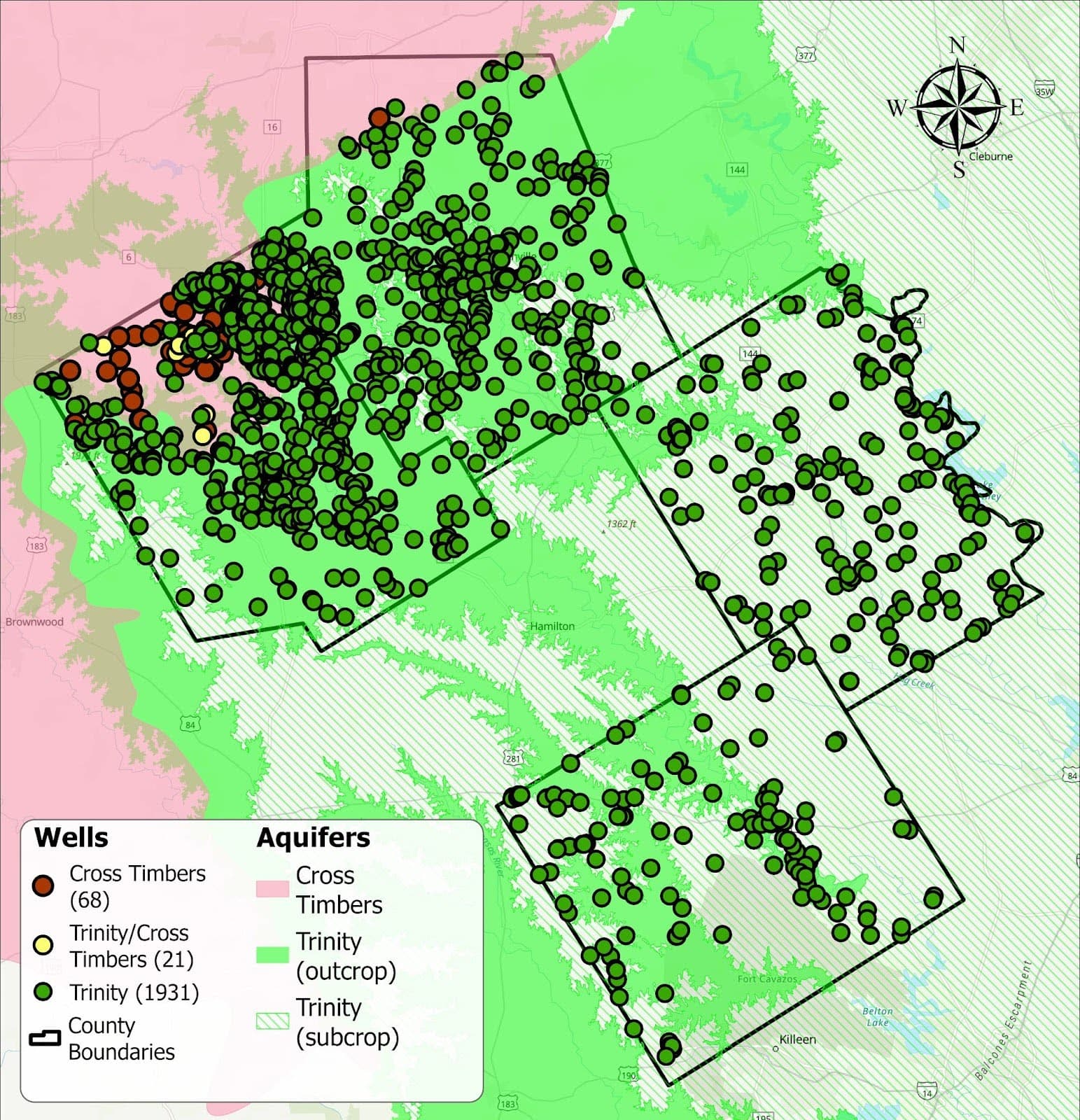
According to the Texas Water Development Board (TWDB) groundwater database, within the four counties of the MTGCD:
- 1,931 wells are screened exclusively in the Trinity Aquifer
- 21 wells open to both the Trinity and Cross Timbers aquifers
- 68 wells screened exclusively in the Cross Timbers Aquifer
Note: These figures reflect only the wells logged in the TWDB database within Comanche, Erath, Bosque, and Coryell counties; actual well counts (including private or unregistered installations) are likely higher.
Enlarged Image
Map of aquifer wells in the Middle Trinity Groundwater Conservation District.
Note: These figures reflect only the wells logged in the TWDB database within Comanche, Erath, Bosque, and Coryell counties; actual well counts (including private or unregistered installations) are likely higher.
Water Quality:
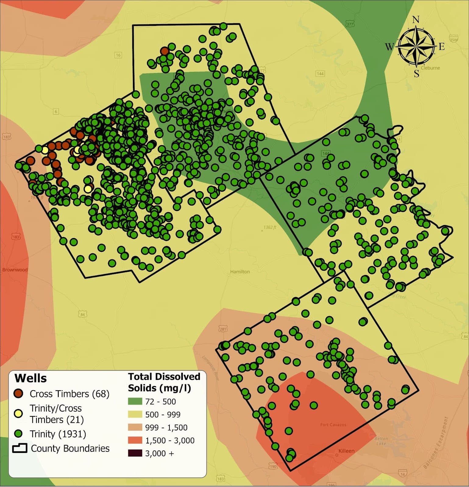
Groundwater salinity in the MTGCD is categorized by total dissolved solids (TDS) as follows:
- Fresh: 0–999 mg/L TDS
- Slightly saline: 1,000–2,999 mg/L TDS
- Moderately saline: 3,000–9,999 mg/L TDS
- Saline (brackish): ≥10,000 mg/L TDS
Note that “brackish” encompasses all waters with TDS ≥1,000 mg/L.
Cross Timbers Aquifer
Groundwater TDS in the Cross Timbers Aquifer spans from fresh to brackish, with significant variability both within and between the Strawn, Canyon, Cisco, and Wichita units. In most wells across the District, water quality ranges from fresh up to slightly saline, thanks in part to cross‑formational flow from the overlying Trinity Aquifer, which dilutes higher‑TDS zones. Locally elevated chloride and TDS levels are attributed to dissolution of native halite lenses in the Paleozoic strata.
Trinity Aquifer
The Trinity Aquifer generally yields fresh to slightly saline water in the MTGCD. Near‑surface units (Paluxy, Hensell) tend toward fresher quality, while deeper horizons—particularly the Hosston Formation—more often approach the upper end of the slightly saline range. Hardness is moderate to high, reflecting calcium and magnesium from sandstone dissolution.
Rainwater Quality
Rainwater is prized for its inherently low mineral content and absence of disinfection by‑products found in treated supply water. However, atmospheric deposition and contact with roofing or collection surfaces can introduce microbes, dissolved organics, and particulates. Before using harvested rainwater for potable purposes, these potential contaminants should be removed via proper filtration, disinfection (e.g., UV or chlorine), and particulate settling.
Currently, neither federal nor Texas state regulations set specific quality standards for harvested rainwater. Homeowners should consult their county health department or local building officials to determine any required testing protocols or permit requirements when rainwater is intended for drinking.
Enlarged Image
Map of wells in the Middle Trinity Groundwater Conservation District and TDS levels in the Trinity Aquifer.
This map portrays the location of wells in the Middle Trinity Groundwater Conservation District and TDS levels through the Trinity Aquifer in the region.